NEW AI METHOD COUNTS MANATEE CLUSTERS IN REAL TIME
by GISELE GALOUSTIAN | Wednesday, Dec 13, 2023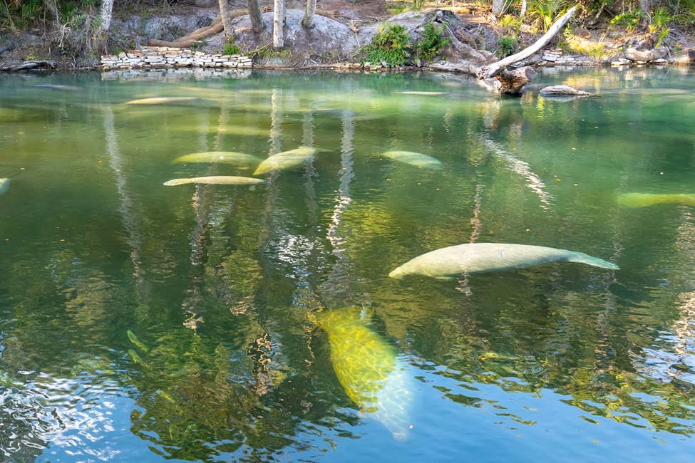
Manatees are endangered species volatile to the environment. Because of their voracious appetites, they often spend up to eight hours a day grazing for food within shallow waters, making them vulnerable to environmental changes and other risks.
Accurately counting manatee aggregations within a region is not only biologically meaningful in observing their habit, but also crucial for designing safety rules for boaters and divers as well as scheduling nursing, intervention, and other plans. Nevertheless, counting manatees is challenging.
Because manatees tend to live in herds, they often block each other when viewed from the surface. As a result, small manatees are likely to be partially or completely blocked from view. In addition, water reflections tend to make manatees invisible, and they also can be mistaken for other objects such as rocks and branches.
While aerial survey data are used in some regions to count manatees, this method is time-consuming and costly, and the accuracy depends on factors such as observer bias, weather conditions and time of day. Moreover, it is crucial to have a low-cost method that provides a real-time count to alert ecologists of threats early to enable them to act proactively to protect manatees.
Artificial intelligence is used in a wide spectrum of fields, and now, researchers from Florida Atlantic University’s College of Engineering and Computer Science have harnessed its powers to help save the beloved manatee. They are among the first to use a deep learning-based crowd counting approach to automatically count the number of manatees in a designated region, using images captured from CCTV cameras, which are readily available, as input.
This pioneering study, published Scientific Reports , not only addresses the technical challenges of counting in complex outdoor environments but also offers potential ways to aid endangered species.
To determine manatee densities and calculate their numbers, researchers used generic images captured from surveillance videos from the water surface. They then used a unique design matching to manatees’ shape – Anisotropic Gaussian Kernel (AGK) – to transform the images into manatee customized density maps, representing manatees’ unique body shapes.
Although many methods exist for counting, most of the existing counting methods are applied to crowds to count the number of people, due to their relevance to important applications such as urban planning and public safety.
To save labeling costs, researchers used line-label based annotation with a single straight line to mark each manatee. The goal of the study was to learn to count the number of objects within a scene and obtain labels to support counting.
Results of the study reveal that the FAU-developed method outperformed other baselines, including the traditional Gaussian kernel-based approach. Transitioning from dot to line labeling also improved wheat head counting accuracy, an important role in crop yield estimation, suggesting broader applications for convex-shaped objects in diverse contexts. This approach worked particularly well when the image had a high density of manatees in a complicated background.
By formatting manatee counting as a deep neural network density estimation learning task, this approach balanced the labeling costs vs. counting efficiency. As a result, this method delivers a simple and high throughput solution for manatee counting that requires very little labeling efforts. A direct impact is that state parks can leverage this method to understand the number of manatees in different regions, by using their existing CCTV cameras, in real time.
“There are many ways to use computational methods to help save endangered species, such as detecting the presence of the species and counting them to collect information about numbers and density,” said Xingquan (Hill) Zhu, Ph.D., senior author, an IEEE Fellow and a professor in FAU’s Department of Electrical Engineering and Computer Science. “Our method considered distortions caused by the perspective between the water space and the image plane. Since the shape of the manatee is closer to an ellipse than a circle, we used AGK to best represent the manatee contour and estimate manatee density in the scene. This allows density map to be more accurate, in terms of mean absolute errors and root mean square error, than other alternatives in estimating manatees’ numbers.”
To validate their method and facilitate further research in this domain, the researchers developed a comprehensive manatee counting dataset, along with their source code, published through GitHub for public access at github.com/yeyimilk/deep-learning-for-manatee-counting.
“Manatees are one of the wildlife species being affected by human-related threats. Therefore, calculating their numbers and gathering patterns in real time is vital for understanding their population dynamics,” said Stella Batalama, Ph.D., dean, FAU College of Engineering and Computer Science. “The methodology developed by professor Zhu and our graduate students provides a promising trajectory for broader applications, especially for convex-shaped objects, to improve counting techniques that may foretell better ecological results from management decisions.”
Manatees can be found from Brazil to Florida and all the way around the Caribbean islands. Some species including the Florida Manatee are considered endangered by the International Union for Conservation of Nature.
Study co-authors are FAU graduate students Zhiqiang Wang; Yiran Pang; and Cihan Ulus, also a teaching assistant, all within the Department of Electrical Engineering and Computer Science.
The research was sponsored by the United States National Science Foundation.
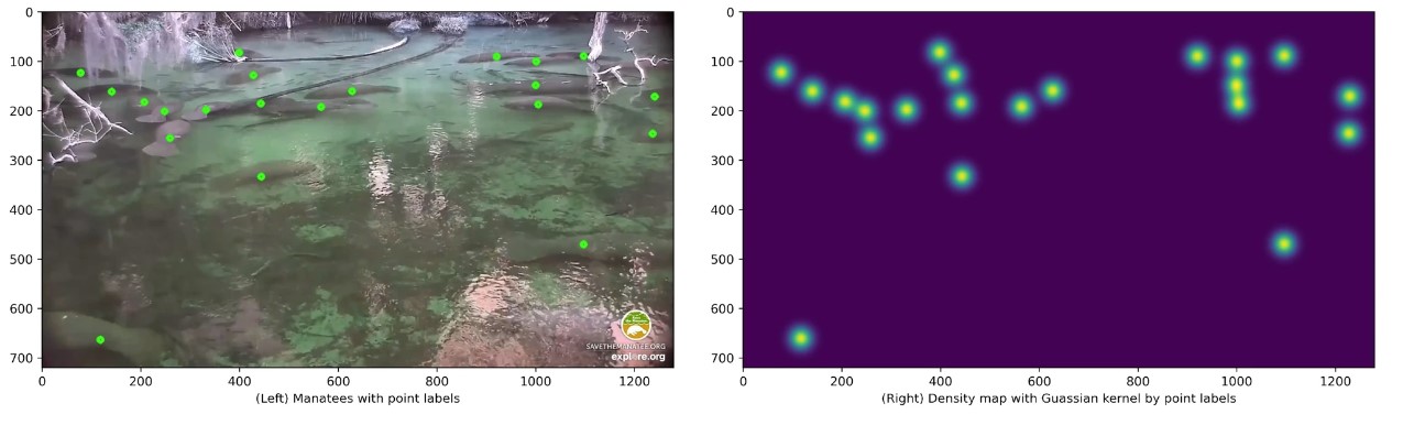
The left panel shows an image with dot labels of manatees and the right panel shows the density map of the image generated by applying Gaussian distributions to the labeled points.
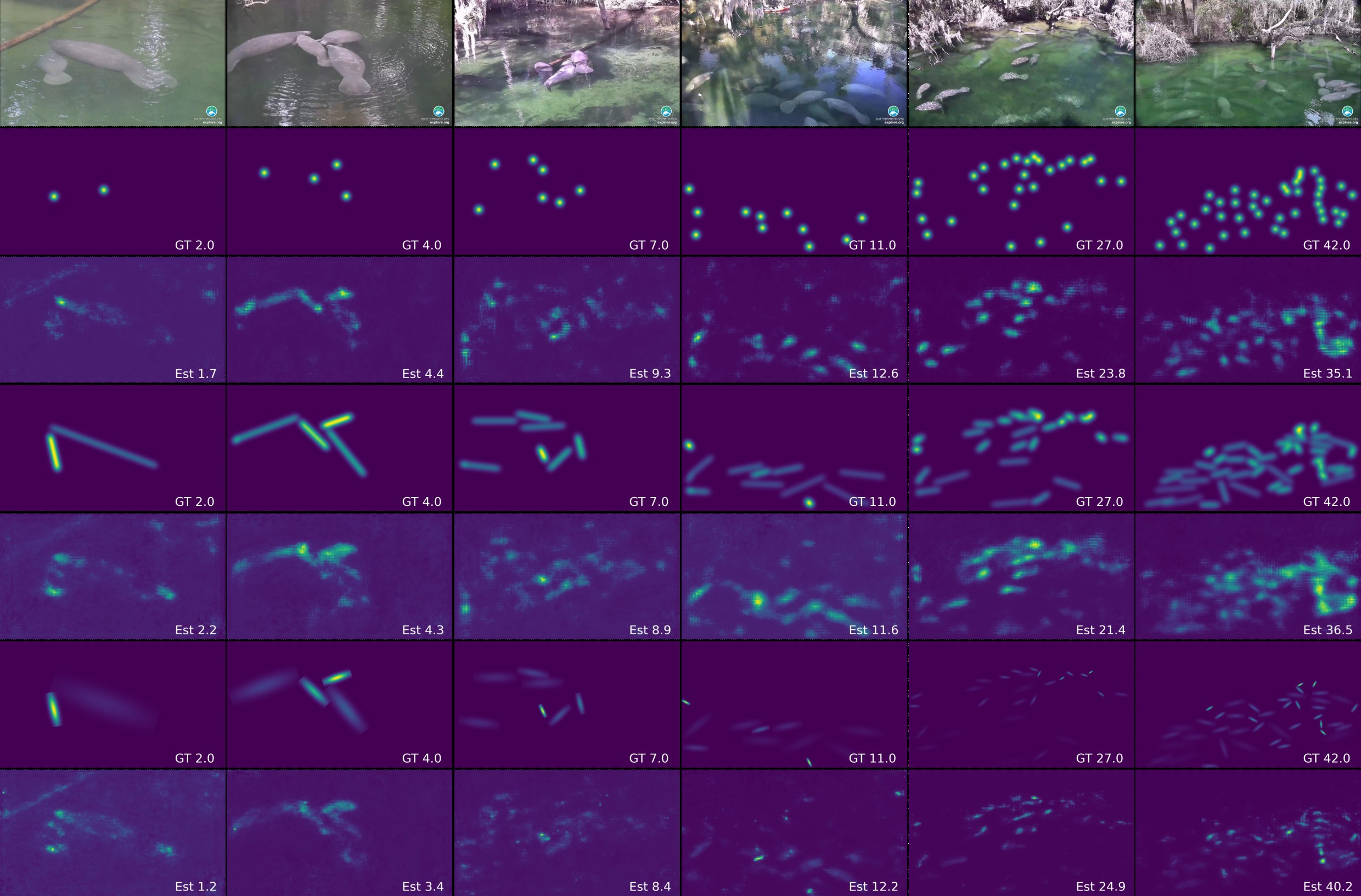
Examples of algorithm performance with respect to different manatee densities in the scene. The first row shows original images with increasing manatee density from left to right. The second and third rows show ground-truth density map (second row) and predicted density map (third row) using dot labels. The fourth and fifth rows show ground-truth density map (fourth row) and predicted density map (fifth row) using line labels and generic Gaussian kernels. The sixth and seventh rows show ground-truth density map (sixth row) and predicted density map (seventh row) using line labels and anisotropic Gaussian kernels.