Immersive, Realistic 3D Virtual Streetscape Infrastructure Modeling across Multiple Software Platforms
REU Scholar: Dana Smith
Research Mentor: Jinwoo Jang, Ph.D.
REU Project: Infrastructure Systems: Human-in-the-loop Digital Twins for Smart Cities
Florida Atlantic University, Department of Civil, Environmental and Geomatics Engineering
Introduction
Photorealistic 3D Maps Tiles
• Encrypted with 3D geodata and images, visualize entire streetscapes: buildings, terrain, roads, forestry, etc. [1-3]
• Urban planning, game development, and transportation through visualizing potential city plans, tourism, and predicting the future housing market. [4-5]
3D immersive digital twin
• Digital replication of an actual structure or object to conduct simulations with real-time data and visualize the impacts of future city plans. [6]
Figure 1. Video of Photorealistic 3D Tiles made by the Google Maps Platform [8]
Objectives
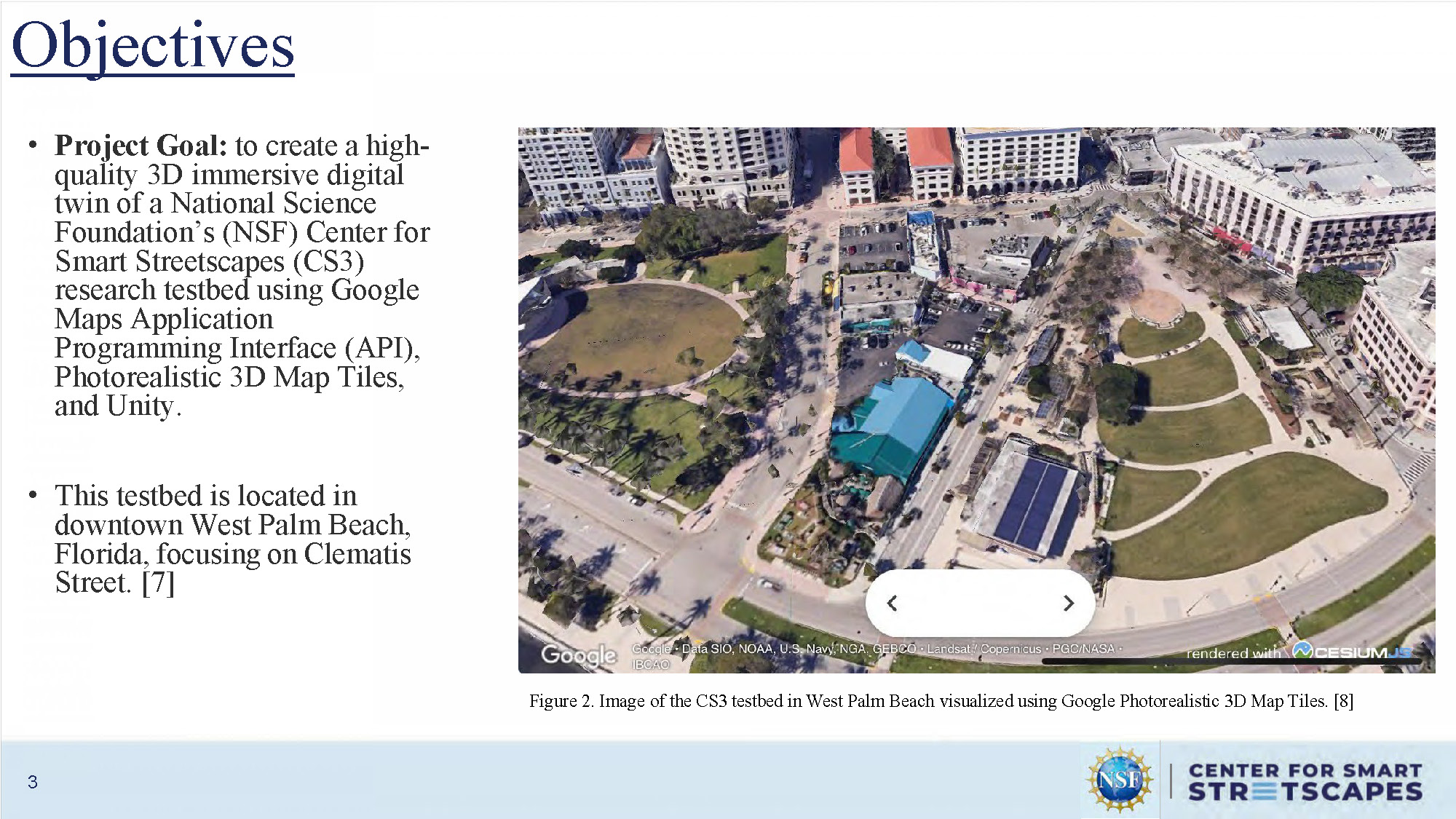
Project Goal: to create a high-quality 3D immersive digital twin of a National Science Foundation's (NSF) Center for Smart Streetscapes (CS3) research testbed using Google Maps Application Programming Interface (API), Photorealistic 3D Map Tiles, and Unity.
This testbed is located in downtown West Palm Beach, Florida, focusing on Clematis Street. [7]
Figure 2. Image of the CS3 testbed in West Palm Beach visualized using Google Photorealistic 3D Map Tiles. [8]
The figure displays a 3D rendered view of Clematis Street in downtown West Palm Beach, showing buildings, street layout, palm trees, and urban infrastructure in photorealistic detail using Google's 3D mapping technology.
Overview
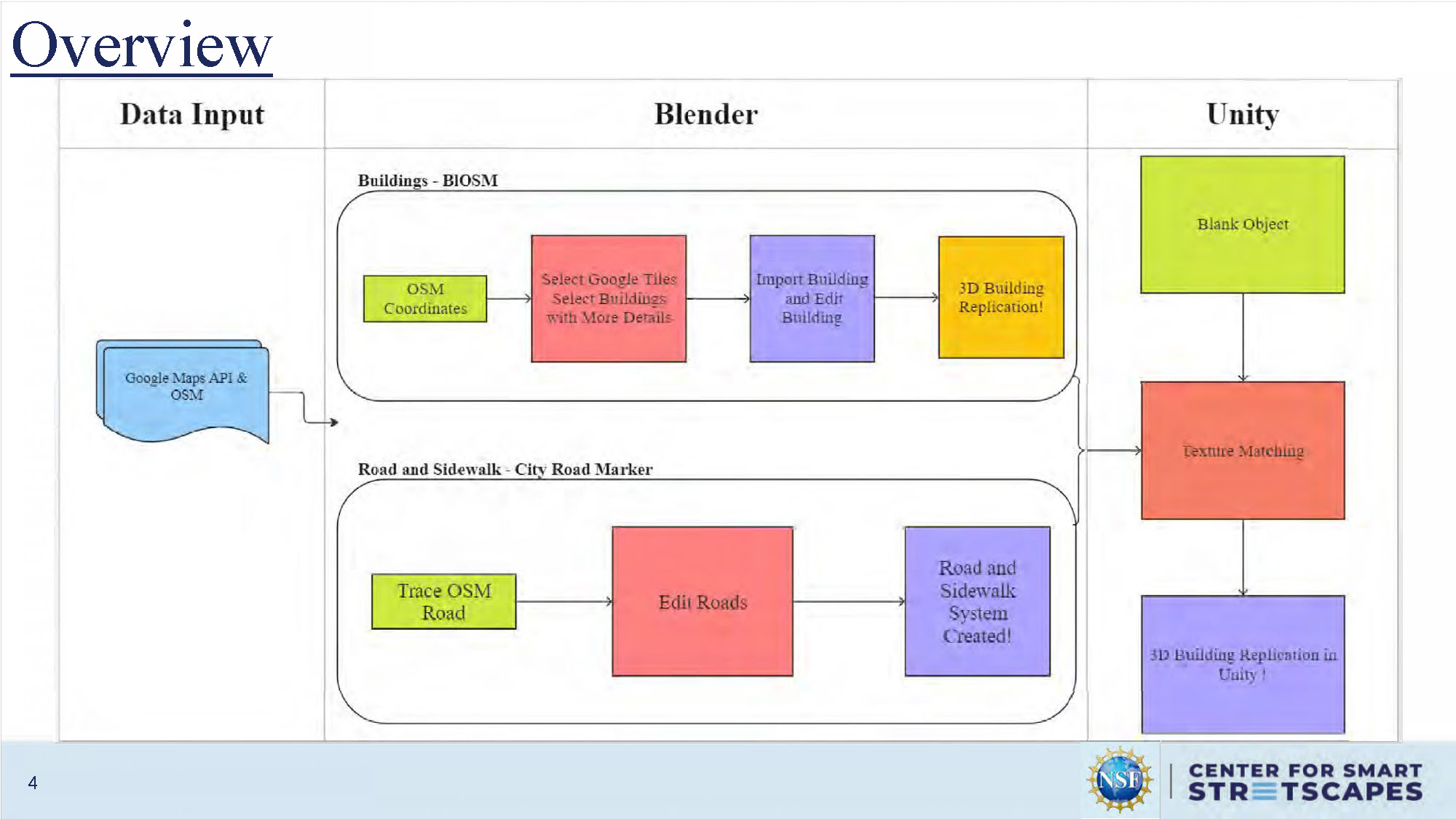
The slide displays a workflow diagram showing the process flow from Google Maps API through various software platforms to create the 3D digital twin. The diagram shows interconnected boxes representing different stages of the modeling process, including data acquisition, processing through Blender, and final implementation in Unity for the immersive digital twin creation.
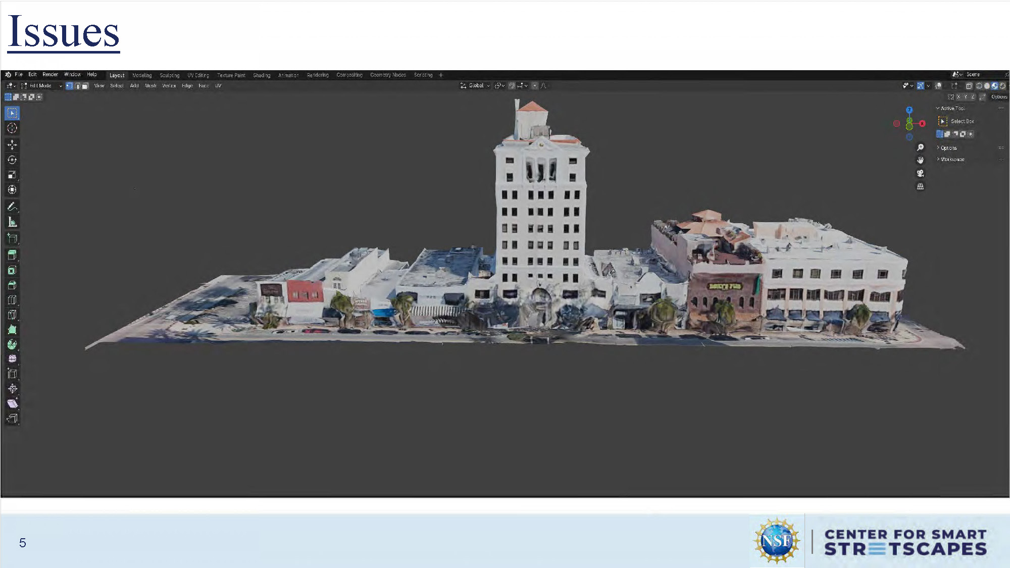
Issues
This slide outlines various technical challenges and limitations encountered during the project implementation, though specific details of the issues are presented in bullet point format on the visual slide.
Methods – Blender
This slide shows screenshots of the Blender software interface being used for 3D modeling of the streetscape. The images demonstrate the 3D modeling environment with various tools, viewports, and the process of creating and refining the digital twin models within Blender's interface.
Methods – Blender
This slide continues to show the Blender modeling process with additional screenshots of the software interface. The images display various stages of 3D model development, including different viewport perspectives and modeling tools being utilized to create accurate representations of the streetscape infrastructure.

Methods – Blender
This slide presents more advanced stages of the Blender modeling process, showing detailed 3D models with texturing and material applications. The screenshots demonstrate the progression from basic geometric models to more refined, textured representations of buildings and streetscape elements.
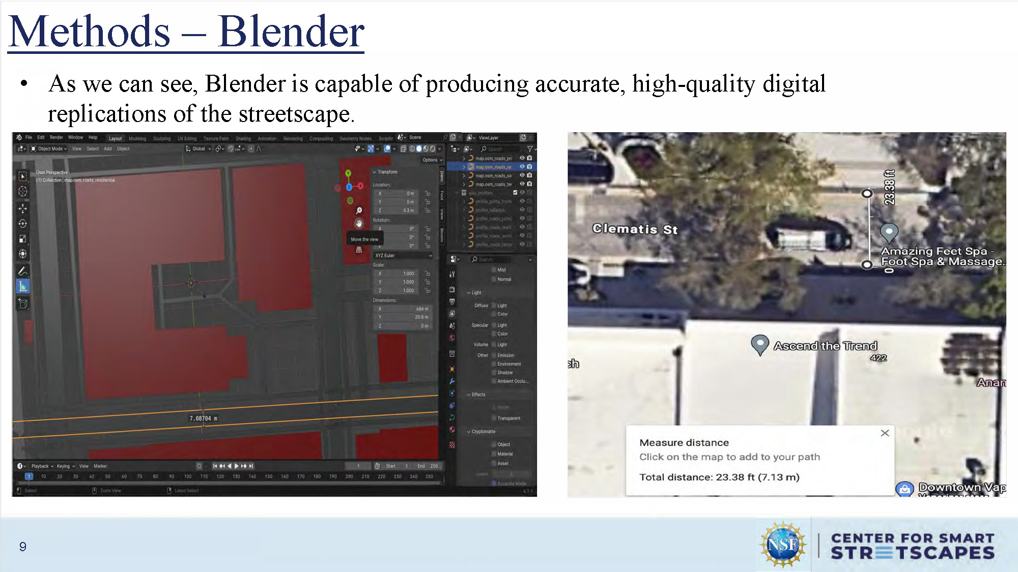
Methods – Blender
As we can see, Blender is capable of producing accurate, high-quality digital replications of the streetscape.
Methods – Blender
This slide displays the final rendered 3D models created in Blender, showing high-quality visual outputs and comparison views that demonstrate the accuracy and detail achieved in the digital replication of the streetscape infrastructure.

Methods – Unity
This slide shows screenshots of the Unity game engine interface being used to implement the 3D digital twin. The images demonstrate the Unity development environment with scene views, asset management, and the integration of the 3D models created in Blender into an interactive, immersive environment.
Methods – Unity
This slide continues to demonstrate the Unity implementation process, showing additional development work including scene setup, lighting configuration, and the arrangement of 3D assets within the Unity environment to create the immersive digital twin experience.

Results
This slide presents the final results of the project, displaying the completed 3D immersive digital twin implementation. The images show the successful integration of all components to create a high-quality, interactive representation of the CS3 testbed streetscape.
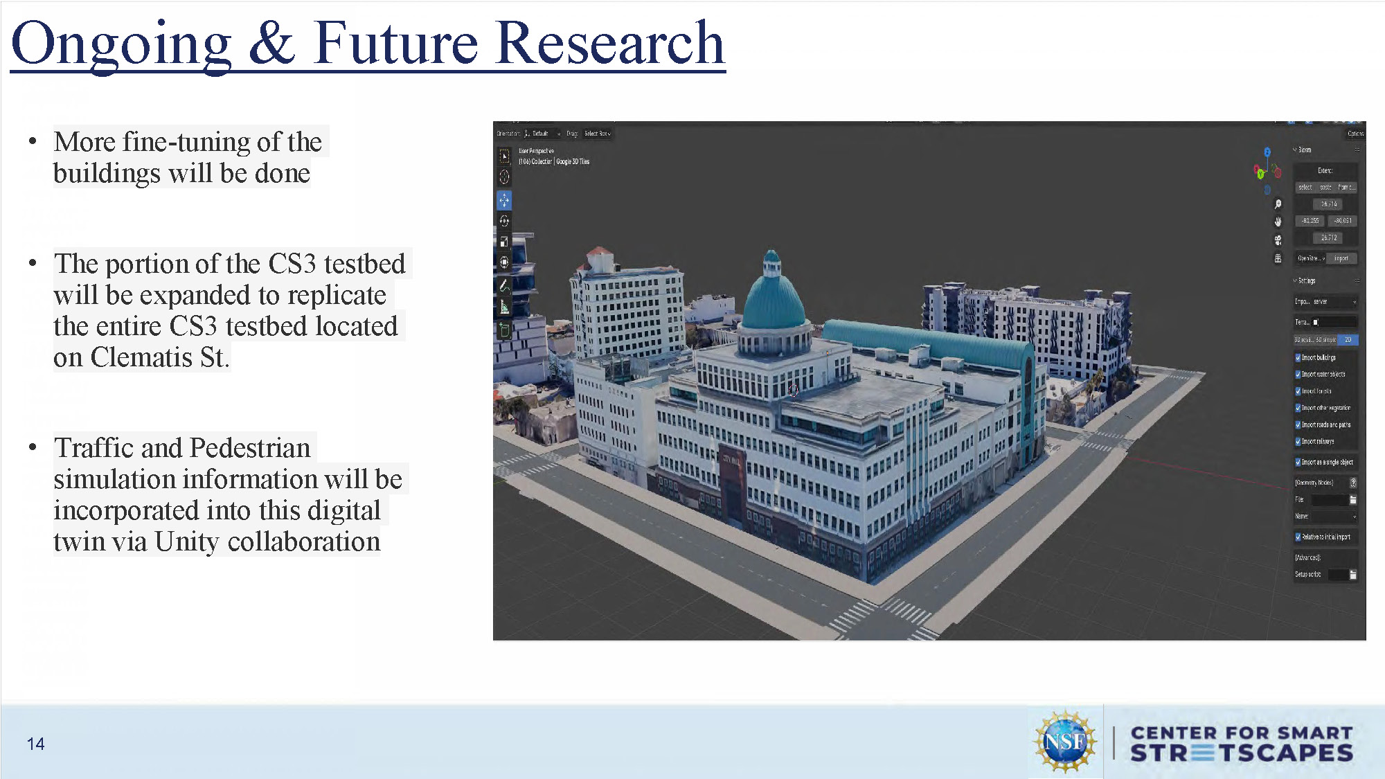
Ongoing & Future Research
More fine-tuning of the buildings will be done
The portion of the CS3 testbed will be expanded to replicate the entire CS3 testbed located on Clematis St.
Traffic and Pedestrian simulation information will be incorporated into this digital twin via Unity collaboration

Conclusion
An accurate immersive 3D high-quality digital twin was created for a portion of the CS3 testbed located in downtown West Palm Beach
I am excited for Google Maps to update their Photorealistic 3D Tiles to minimize building distortion.
Acknowledgment
This work was fully supported by the U.S. National Science Foundation (EEC- 2133516).

References
- Photorealistic 3D tiles. (n.d.-b). Google for Developers. https://developers.google.com/maps/documentation/tile/3d-tiles
- Photorealistic 3D Tiles overview. (n.d.). Google for Developers. https://developers.google.com/maps/documentation/tile/3d-tiles-overview
- Photorealistic 3D tiles. (n.d.-c). https://3d-tiles.web.app/#flight
- Photorealistic 3D tiles. (n.d.-d). https://3d-tiles.web.app/#data-viz
- Build immersive maps at scale with photorealistic 3D, 2D, and street view tiles, now in GA – Google Maps platform. (n.d.). Google Maps Platform. https://mapsplatform.google.com/resources/blog/build-immersive-maps-at-scale-with-photorealistic-3d-2d-and-street-view-tiles-now-in-ga/#:~:text=Photorealistic%203D%20Tiles%20The%20visualization%20shows%203D,based%20on%20transportation%2C%20building%2C%20and%20market%20forecasts.
- Hansen, M. (2023, September 26). The future of innovation: immersive digital twins. Kinetic Vision. https://kinetic-vision.com/the-future-of-innovation-immersive-digital-twins/
- Center for Smart Streetscapes. (n.d.). https://cs3-erc.org/research/
- Photorealistic 3D tiles. (n.d.-a). https://3d-tiles.web.app/#orbit
- Blosm for Blender: Google 3D cities, OpenStreetMap, terrain. (n.d.). Gumroad. https://prochitecture.gumroad.com/l/blender-osm
- Bos, L. (2023, October 26). Photorealistic 3D Tiles from Google Maps Platform Now Included in Cesium ion. Cesium. https://cesium.com/blog/2023/10/26/photorealistic-3d-tiles-in-cesium-ion/
- Photorealistic 3D tiles. (n.d.-e). https://3d-tiles.web.app/#globe-view

Questions & Feedback
End of Presentation
Click the right arrow to return to the beginning of the slide show.
For a downloadable version of this presentation, email: I-SENSE@FAU.