Study Finds Massive Loss of U.S. Coastline Tidal Flats Over 31 Years
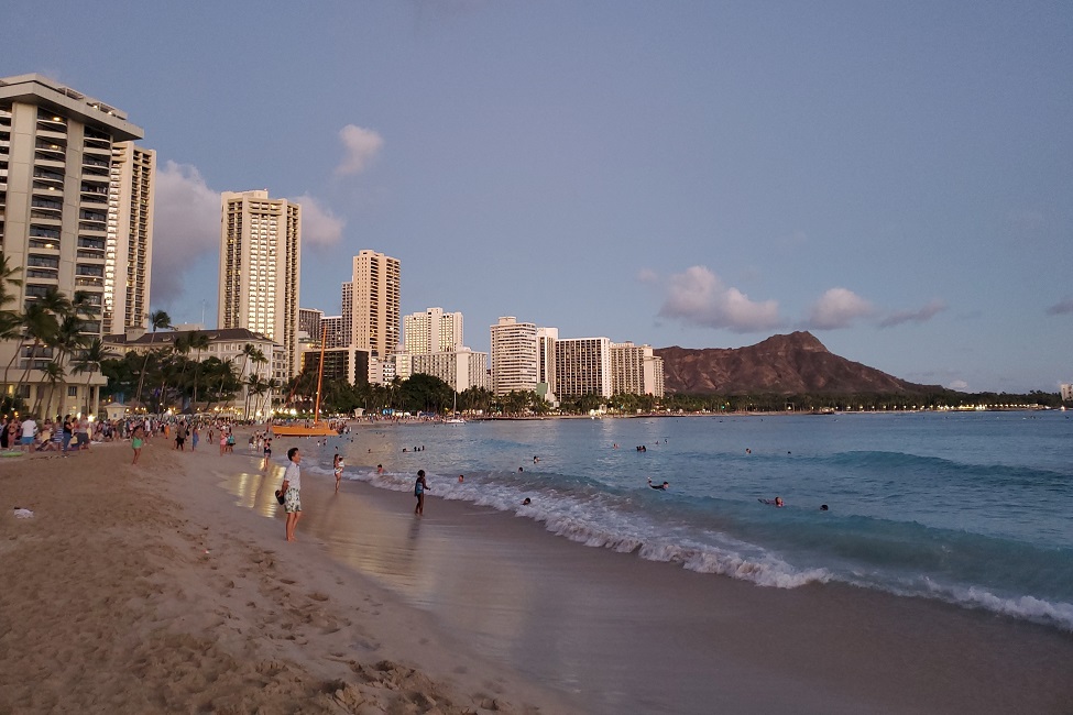
A beachfront demonstrates how an urban area touches and affects the coastal environment. (Photo credit: Chao Xu, Ph.D.)
Tidal flats, also known as mud flats, make up coastal wetlands that protect against destructive powers from the ocean such as waves, tsunamis and hurricanes. These guardians of the coastlines, however, are under threat due to natural and human events. Climate change including sea level rise and rapid urbanization have resulted in a “coastal squeeze” between land and sea. More than 20,000 kilometers of tidal flats have shrunk worldwide since 1984. In the U.S., human development has made irreversible damages to tidal flats.
To date, research investigating patterns of tidal flat loss due to urban expansion has only been conducted in small areas. For the first time, a new Florida Atlantic University study provides a “big picture” examination that demonstrates the impacts of urban expansion on tidal flat environments across the contiguous U.S.
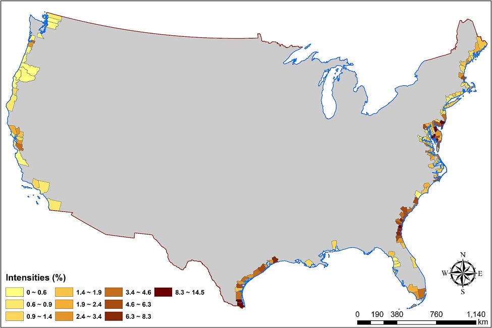
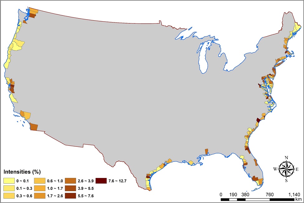
Out of 226 seaside counties, researchers selected 156 that were directly by the seaside and had a share of tidal flats greater than 1 percent as of 1985. They examined data from 1985 to 2015 to identify change patterns of tidal flats and urbanization in those counties, of which 76 percent were by the seaside, and assessed correlations between tidal flat loss and urban expansion. They used annual maps of tidal flats and urban expansions and a pixel-based approach to track and analyze land cover transitions. They overlapped the maps to conduct a series of correlation assessments between urban expansion and tidal flat erosion over the 31-year study period.
Results of the study, published in the journal Science of The Total Environment , reveal how human activities, rather than natural factors, have impacted tidal flat environments in the contiguous U.S. Urban expansions have not only substantially squeezed the space of tidal flats, but also significantly affected the surrounding tidal flat environments over three decades. Tidal flats surrounding new urban areas have undergone considerable degeneration and the patterns appear more significant as they get closer to new urban locations.
For the study, researchers divided the 156 counties into four groups: Northern Atlantic Coast (Zone A); Southern Atlantic Coast (Zone B); the Gulf Coast (Zone C); and the Pacific Coast (Zone D). These counties were grouped into four zones based on administrative divisions and geographical factors.
The contiguous U.S. has shorelines in the north (Great Lakes), east (Atlantic Ocean), south (Gulf Coast) and west (Pacific Ocean). Except for the Great Lakes, all these shorelines are seashores.
Findings from the study reveal massive urban expansions throughout the entire contiguous coastal U.S., in which the Atlantic Coast shows outstandingly high rates. The top eight are all in this area: Prince William County, Virginia; Horry County, South Carolina; the City of Newport News, Virginia; Gloucester County, Virginia; Richmond County, New York; New Hanover County, North Carolina; the City of Hampton, Virginia; and Duval County, Florida.
Findings also show several cities have considerably affected nearby tidal flats while expanding urban areas, including Boston; Wilmington, North Carolina; Charleston, South Carolina; Savannah, Georgia; Jacksonville; Palm Bay; Fort Myers; Tampa; Houston, Corpus Christi, Texas; and San Jose, California.
In contrast, three major cities – New York City, Miami and Seattle – have had significant urban expansions, but they do not overlap the large clusters of tidal flat erosions. This finding suggests that tidal flats are not a major land source for urban expansions in these three cities. Instead, New York City, Miami and Seattle relied highly on other land sources over the three decades.
Researchers also identified the largest tidal flat cluster from South Carolina and Georgia in Zone B, which is followed by Delmarva Peninsula in the eastern shore of Delaware, in Zone A, Southern Coastal Texas in Zone C, and the San Francisco Bay Area in Zone D.
While the Atlantic Coast, which belongs to Zone A and Zone B, has been rapidly urbanized during the three decades, the rates of urbanization in the other two zones (Zone C and Zone D) are relatively mild. This preliminary observation suggests some intersections between tidal flat erosions and urban expansions.
Researchers identified some clusters of tidal flat erosion that do not greatly overlap the new urban areas. This is likely because sediment discharge by major rivers or river sloughs, which is one of the critical factors to maintain the extents of tidal flats, are likely slowing down or stopping the process of tidal flat shrinkages.
“Findings from our study provide important implications for coastal land use and planning to sustain tidal flats,” said Weibo Liu, Ph.D., senior author and an associate professor in the Department of Geosciences within FAU’s Charles E. Schmidt College of Science. “Our study provides worthwhile data for scientists and lawmakers alike that will contribute to helping to develop policy and programs that address how massive urban expansion has tremendously undermined the environment of tidal flats along the U.S. coast.”
The researchers provide two important key takeaways from this research. First, local officials should ensure that water channels are unobstructed. Water channels are waterways between two landmasses that are critical for transporting sediment and deposition. Second, they urge leaving sufficient space for the migration of tidal flats. The sustainable management for tidal flats should particularly acknowledge hydrodynamical factors as well as the ongoing crisis of sea level rise.
“Tidal flats have been severely inundated due to sea level rise,” said Chao Xu, Ph.D., an FAU graduate from the Charles E. Schmidt College of Science who is now an assistant professor of practice in the Department of Geosciences at Texas Tech University. “If we don’t leave some inland spaces for tidal flats to move around, they will likely disappear, which will have dire consequences for beachfront communities.”
-FAU-
Tags: students | science | research | faculty and staff